Air cargo transport baselines
These baselines are based on data available in NTMCalc 4.0, literature reviews and expert interviews. The settings aim to reflect on general air cargo transport. In general we recommend use of real data if available at sufficient quality. NTM default data are conservatively assessed and should if used thereby not enable low emission calculations. Furthermore they should promote transport suppliers to present their real data in relation to NTM default data, hence being used in the transport service procurement process.
Providing default data for air transport will by definition entail an element of incorrect emissions and energy use assessment. The main reason is that air emission factors are not linear with distance:
Flying longer distance requires more fuel which adds to gross weight and thereby increases environmental impact itself. In effect this means that every individual flight have its specific emissions.
Another aspect is that the general flying cycle include lift and take-off, cruising and descend. Since the relative impact from cruising is lower than lift and take off means that shorter flights should have a relatively higher impact per shipment.
For this assessment the emissions on high altitude is considered equal to emissions at ground level. This question is controversial as many climate experts claim that high altitude GHG-emissions should be higher than the actual emissions. In order to take this into consideration in a practical way, CO2-emissions are multiplied by a factor (radiative forcing index) linked to altitude. Long distance flights are normally at higher altitude than regional flights. This factor is set differently by different experts at 1-5 depending on flying altitude and underlying physics. At this stage NTM does not include this factor for default aircrafts. Read more
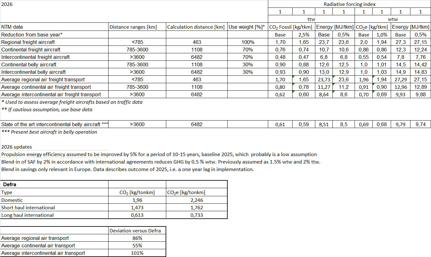
The below data is based on NTMCalc 4.0 and includes range based average aircrafts on a specified distance. The aircrafts are divided between regular freight aircrafts and belly aircrafts (passenger air crafts carrying additional cargo). The range based average aircrafts are a mix of reasonable aircrafts for different distances. The major update of these data refers to a shift towards use of more freighters due to severe reduction of passenger flights as a result of the Corona pandemic.
In order to provide general average aircrafts independently of its configuration (freighter/belly freighter) three average aircrafts (green labeled) has in addition been designed based on general air traffic data.
For a more specific calculation it should be carried out based on real data from supplier or actual settings of aircraft used in NTMCalc.
Read more;


Clarifications and abbreviations
NTM data
Describes type of aircraft. Default freight and belly freight aircrafts within NTMCalc are generically derived through different specific aircrafts:
Regional
ATR 42-300 Freighter and F 27 – 500
Continental
B 757 – 200F, B757 – 200PF and A 300 Freighter
Intercontinental
MD – 11F, B 777 – 200F
Calculation distance
Refers to actual distance when calculating emissions
Energy
Use of energy, including fuel production/ distribution and the combustion (wtw). Only combustion is ttw.
CO2e
Emissions of carbon dioxide equivalents including fuel production, distribution and the combustion (wtw).
CO2 fossil
Emissions of fossil carbon dioxide in the combustion phase (ttw).
Sourc
NTMCalc 4.0; www.transportmeasures.org
Read more;